Photos by Justin Fort
If your backyard is in Southern California, namely Orange or Riverside Counties, a weeks worth of off-road adventurism is as close as the lump that separates the 5 and the 15 the Saddleback Ridge complex. Yup, that lump, the Santa Ana Mountains, to the east of the hyper-developed Orange County mall-parking-coffee-center and ex-land protectorate established by James Irvine (sniff tears), Oakley headquarters, old bombing ranges now housing tracts, some sand, plus the lovely flammable nook of Laguna Beach. The same ridge is the one over what sets the sun for all the just-add-water communities clustered along the 15. Entry to the trails can be found from all four sides.
A combination of about 10 peaks and the saddles and ridges betwixt, most of the available Saddleback Ridge area (more than 200 miles square, all told) is national land. The Cleveland National Forest is part of the patchwork of national land sprinkled up and down the state. Dont delay your exploration, especially of the fascinating mining and rural remnants lots of cool history is being cleaned up by the forest service (especially since a big stimulus gift wad landed in their lap rumored to be anywhere between $76 and $600 million). Also keep in mind that a certain set of manners is prescribed when playing in park land (your land, lets be frank), and its essential you behave to preserve our access to the CleveNat. Dont give the hippiecrites an opportunity to blame you for tearing up the wilderness when we all know the only folks hauling garbage off the mountain (and broken bicyclists - frequently) are the people with a truck to carry em. Contact the local ranger district for more info about whats good-boy and whats not, and show the rangers why the white-collar whiners who complain about trucks are one energy bar past proper inflation.

The action to be had amongst Los Pinos, Trabuco, Bald, Pleasant, Sierra and Santiago (originally called Saddleback) Peaks is neatly illustrated in state-specific map books. Weve used Benchmark Maps California Road & Recreation Atlas to good effect, and though its not GPS, theres more context to be had in print. Maps make it easy to slide your eyes sideways and identify what peak youre rounding, and when visibility turns to crap in the fog or at night, a map can save your ass if you prefer not being eaten by whatever lives in the bushes. There are also a number of sensible off-roading websites starting with Off-Road.com if you like to get your facts online. Dirtopia.com is a pure trail Wiki, and sports quality background on the CleveNat.
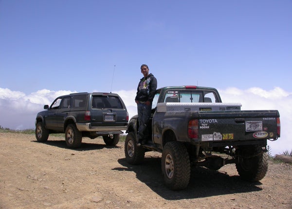
A few trips up and down the ridge went into bolting this coverage together, via both counties bookending the area, most with a crew of fellow rough riders. It helps to travel with company, especially if youre a dumbass. None of the trails in the Santa Anas are impossible, but a few are beyond the capabilities of unmodified trucks, the underequipped, under-intelligent or those under the influence. Some of our brunch runs were admittedly solo; low-pro AM blasts out of Rancho Santa Fe to break open a picnic basket at the top of the ridge. On a few occasions, the busy ridge routes (full of hikers, bikers, enduro guys and off-roaders all licensed vehicles, as is the rule in the CleveNat) produced other groups of vehicles what wed join for an afternoons exploration.
Obligatory Stupid People Warning
Dont be these guys: in 2009, we were puzzling our way through a debilitating dusk fog (practicing for trail runs in Oregon, apparently) and nearly ran over some folk. These three had hung up their bone-stock two-by F-150 on a spur trail north of Beeks Place, and were walking out. Though having already hoofed it for an hour when we found them, they were still more than an hours drive from pavement. Despite our suspicions (which can lead you to getting shot in these parts be polite), we followed them and yanked their bucket back on-course. Ruined a tow strap in the process, too, so now we get a deposit from strangers before pulling em out.
Had we not ventured down that seldom-used trail looking for the top end of Black Star, three boobs would have spent the evening as cougar bait, perhaps contributing one more batch of ghosts to Black Stars established specters. Though there havent been any recent sasquatch sightings on the Saddleback Ridge complex, the big cats are a regular hazard. Dont be stupid: use your head, travel with friends, keep kids and dogs within spitting distance, and dont add yourself to the pile of BS that the trail-closure fiends whine about to keep off-roaders out.
Saddleback Access De Jour: Southern

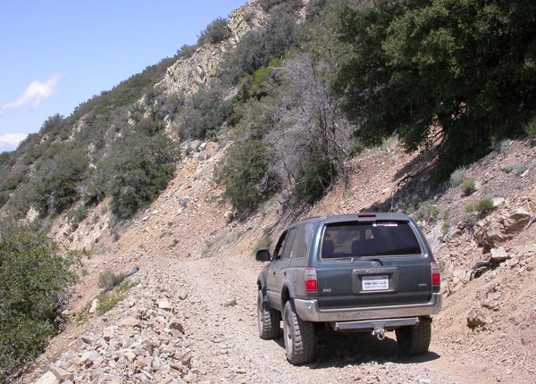
The primary spinal trail along the ridge is N. Main Divide Road (the 3S04). Its composition is stable enough that basic off-road skills, appropriate tires, the option of four-wheel drive and a minimum of Subaru Forester ground clearance can handle the easiest of it. N. Main Divide passes the three main peaks, and with proper permission can get you all the way from the 74 (Ortega) to the 91 in Corona. Weve seen lesser vehicles on the trail, but theyre usually commanded by Grade-A morons and kids who think theyre being sneaky by meeting friends on the ridge to party (and for whom the rangers sweep regularly). A run from end to end on 3S04 (including egress to pavement) can take a day, so dont plan to squeeze in a full run before lunch.
Legal access to the southern end of the Saddleback Ridge complex is available at two points along Ortega Highway (SR74), each of which are closer to Lake Elsinore than the 5. Long Canyon Road (6S05) is the first youll encounter heading east, 10 minutes past the San Juan ranger station. Fifty yards past the El Cariso fire station youll see the 3S04 turnoff. Both go left, and meet at the unpaved trailhead. Wed seen these turnoffs countless times while chasing the crotch-rocket guys up and down Ortega in the STi (this road is always full of fast guys signal your turns in advance and keep an eye in the mirror), so it was a treat to finally explore them.
, you will find places to play on the ridge. Tread lightly doesnt mean stop treading.")
A 10-minute climb up semi-improved roadbed is necessary before hitting dirt (a Y intersection easily identified by one of the parks medieval white swing-gates), so wait until you reach the gate to air down. Weve done the entirety of this trail complex with our Wranglers at 35 psi, though in a few spots 20 psi would have been nice. Beyond enhanced traction, low psi also smoothes the ride in the lumpies. Headed roughly north from the southern entrances, your first big intersection is the fork at Indian Truck Trail (5S01), which lies just past Trabuco Peak (east of N. Main Divide). Take that right, and the truck trail will bring you back to the 15 along a tame ridge route with a few gnarly bypasses that are tougher than they look (and through another unfinished Riverside subdivision pick your exit politely). At the same intersection, a slight left-right uphill jog will keep you on the 3S04, bound for the antennas at Old Saddleback and points north, and the densely forested canyon switchback at the top of Holy Jim Trail (groovy spot).
For a long time after the 2007 fires, this right turn was your only option, as trails and local flora were reinvigorated further north on the 3S04. CleveNat access info, maps of burn areas, and details of repair efforts and other goings-on are available online through the Forest Departments websites. This is a good place to start: fs.fed.us/r5/cleveland/conditions/index.shtml.
Saddleback from the West
Orange Countys favorite CleveNat access is Maple Springs Road past the shoehorn town of Silverado, straight out of Orange County, and a shade north of Holy Jim Canyon and Cooks Corner along the S18 (Santiago Canyon Road). Holy Jim, off Live Oak Canyon Road (the S19) is also known as Trabuco Canyon, a popular Orange County spot to play in the dirt, but it no longer connects to N. Main Divide unless youre on a bike or foot (or really good at muscling an enduro or dirt bike around). Maple Springs Road (5S04) has no such problem, and in less than an hour delivers you to the intersection of Harding Road (the 5S08, closed for now politely ask the ranger about access) and N. Main Divide, about as close to the middle of the Saddleback complex as youre going to get without a helicopter. A fine newbie moment is to be had about a third of the way up Maple Springs, not far past the end of the pavement, where on a stiff right-hand switchback (uphill) if you look left and down youll see at least two trucks that missed the turn by about 100 feet, plus a barbecue.
, we were hit with fog, rain, sleet and sun in the span of five minutes. Coolest place in Orange County.")
The relatively direct nature of the Maple Springs route to the ridge route means a brunch run from Orange County is a realistic a.m. option. You can also pick up Santiago Canyon Road headed southeast out of Lemon Heights and Villa Park, just east of the 241 toll corridor. Be sure to keep the folks in Silverado and elsewhere along the canyon corridor on the off-roaders side: patronize local businesses.
Not open now (though with your persistent requests, this could change), Black Star Mountain Road (SR82) is a quick turn north off Maple Springs and purportedly leads to one of the most haunted places in Orange County. Folks did bad things to other folks in Black Star Canyon back when California wasnt so boring. That, and about three years ago someone heisted 250 pounds of very old dynamite from a quarry up there, and no one has figured out where it went (which means it probably didnt get far). Note: dont let a few folks elitism keep taxpayers from enjoying their right of way through there remember to ask the rangers about improved access and opening trails like Black Star. There are lots of folks who arent physically able to ride or hike 10 miles, including your grandparents, your kids, wounded veterans, the handicapped and all your fat friends, and maybe, just maybe, you dont feel like pedaling. You should have the right not to.
Saddleback from the East
, Group Two paused with southern N. Main Divide over its collective shoulder over there.")
There were originally four access points to Saddleback/CleveNat from the east, but two are now restricted. Someone got selfish and sold the land at the bottom of Eagles Drive (the 4S07), so its locked from above and blocked from below. A lawsuit would probably return public access, as the publics right to be in public lands usually trumps properties that arent protected by grandfatherisms. The northernmost eastward access to N. Main Divide is via Skyline Drive (the 1712) in the back of Corona, and it links up to the spinal trail just north of Beeks Place (which currently has active beehives stored there, so picnic at the Doppler antenna instead), but the lower end is locked and you need to get permission and a key from the rangers based in Riverside. Ask nicely. Weve been told its a long-term right-of-use sort of key, so dont screw it up for everyone else. The aforementioned 5S01, Indian Truck Trail, has always been open, and gets a relatively large amount of traffic, seeing as it dumps out almost directly to the 15. Bedford Road is another quick run from the 15, but to be honest, the last time we used Bedford it might have been Eagles or Skyline, because it was the same foggy afternoon from whence we rescued the F-150, and any one of them would have gotten us downhill. We did reach the bottom, though, and it only took a little maneuvering to exit to the street it was probably legal.
Saddleback from the North
, the also-groovy Doppler radar golfball nearby served as a substitute scenic spot for a picnic.")
The northern end of the Saddleback Ridge complex is somewhat flatter and open, with terrain conducive to the historic rep of the area (and a few scenic bypasses). Want some history? Local Indians used these high pastures to stay cool in the summer, but they wouldnt leave the Spanish settlers horses alone (lets just say the Indians werent horsenapping the beasts to ride them). Local tribes would stash the stolen horses high in the hills thinking they were out of reach of the Spanish, but they couldnt hide from a hardened band of American trappers hired to retrieve the missionaries ponies. Now the tribes get to be a Black Star ghost story instead Several ranches have existed up here, including part of James Irvines original property, and a few still operate to some extent. Theres the old Black Star mining area, and Beeks Place, owned by the ferry magnate Beeks family as a private hunting getaway. Remember, if you dont speak up about four-tired access, only the pedalers will get to play here. Unlike the wonderful state of Colorado (where they share), in California, truck access is being taken away piece by piece. Dont let it happen.
Though Skyline Drive has become the northern access of choice in the last few years, another little-used road runs up from the 91. Coal Canyon was reportedly used frequently in the good old days, according to folks older than us in the same line of adventure, but its currently closed from the top at the antennas and we havent been able to find the access point off the 91 at the bottom. Its old Exit 42 from the 91, in the Santa Ana Canyon (reported closed), but we need to poke around and find out more about why its unavailable. The bikers and hikers still seem to have access from Green River Road, but were not big on foot-only here share the trail with everybody. Is there a truck in your driveway? Find a trail for it.
|
Off-Road.com Newsletter Join our Weekly Newsletter to get the latest off-road news, reviews, events, and alerts! |
Follow @Off-Road
 Your Privacy Choices